

The areas adjoining westcentral and south Arabian Sea and those along the north Kerala-Karnataka-Goa coasts to experience squally winds with speed 40-50 km per hour to 60 km per hour.

A cyclonic storm that formed over east-central and adjoining southeast Arabian Sea near Goa at 11.30 pm on Tuesday, is likely to move nearly northwards and intensify into a severe cyclonic storm, and then into a very severe cyclonic storm during the next 24 hours, the India meteorological department (IMD) said in its morning bulletin.
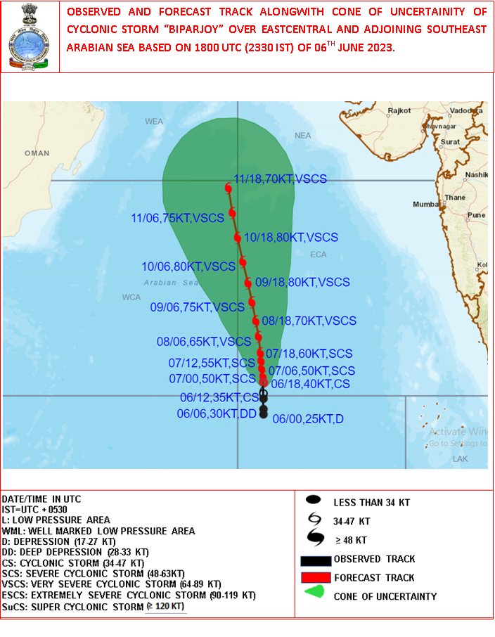
“The cyclonic storm ‘Biparjoy’ (pronounced as ‘Biporjoy’) over eastcentral and adjoining southeast Arabian Sea remained practically s stationary during last 3 hours and lay centred at 0230 hours IST of 7th June, 2023 over the same region near latitude 12.5°N and longitude 66.0°E, about 900 km west-southwest of Goa, 1,020 km southwest of Mumbai, 1,090 km south-southwest of Porbandar and 1380 km south of Karachi,” the meteorological department bulletin read,
Gale winds with speed 80-90 km per hour to 100 km per hour are expected to prevail over the eastcentral Arabian Sea and the adjoining areas of westcentral and southeast Arabian Sea. It is likely to escalate to 105-115 km per hour to 125 km per hour over the same area from Wednesday evening. the IMD said. The areas adjoining westcentral and south Arabian Sea and those along the north Kerala-Karnataka-Goa coasts are likely to experience squally winds with speed 40-50 km per hour to 60 km per hour.
According to the IMD, the intensity of Cyclone Biparjoy, its location of formation in the Arabian Sea and its subsequent movement are likely to affect the onset of the southwest monsoon over Kerala.
This is the second cyclone to form within three weeks in the North Indian Ocean. Cyclone Mocha, which formed in the Bay of Bengal, barrelled into Bangladesh and Myanmar causing massive destruction.
In 2021, Cyclone Yaas had formed at the time of the monsoon onset.